


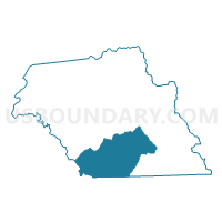
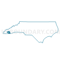
Voting District 11, Macon County, North Carolina
About
Outline

Summary
| Unique Area Identifier | 640660 |
| Name | Voting District 11 |
| County | Macon County |
| State | North Carolina |
| Area (square miles) | 74.13 |
| Land Area (square miles) | 73.98 |
| Water Area (square miles) | 0.16 |
| % of Land Area | 99.79 |
| % of Water Area | 0.21 |
| Latitude of the Internal Point | 35.04703780 |
| Longtitude of the Internal Point | -83.43039470 |
Maps

Graphs
Select a template below for downloading or customizing gragh for Voting District 11, Macon County, North Carolina


Neighbors
Neighoring Voting District (by Name) Neighboring Voting District on the Map
- Voting District 03, Macon County, NC
- Voting District 05, Macon County, NC
- Voting District 07, Macon County, NC
- Voting District 08, Macon County, NC
- Voting District 09, Macon County, NC
- Voting District 10, Macon County, NC
- Voting District 12, Macon County, NC
- 2410556 - VALLEY Voting District, Rabun County, GA
- 2410636 - PERSIMMON Voting District, Rabun County, GA
- Voting District SHCR, Clay County, NC
Top 10 Neighboring County Subdivision (by Population) Neighboring County Subdivision on the Map
- Franklin township, Macon County, NC (14,509)
- Clayton CCD, Rabun County, GA (6,183)
- Mountain City CCD, Rabun County, GA (5,207)
- Smithbridge township, Macon County, NC (3,858)
- Ellijay township, Macon County, NC (2,691)
- Highlands township, Macon County, NC (2,668)
- Cartoogechaye township, Macon County, NC (2,436)
- Shooting Creek township, Clay County, NC (1,513)
- Sugarfork township, Macon County, NC (523)
- Flats township, Macon County, NC (466)
Top 10 Neighboring Place (by Population) Neighboring Place on the Map
Top 10 Neighboring Unified School District (by Population) Neighboring Unified School District on the Map
- Macon County Schools, NC (33,922)
- Rabun County School District, GA (16,276)
- Clay County Schools, NC (10,587)
Top 10 Neighboring State Legislative District Lower Chamber (by Population) Neighboring State Legislative District Lower Chamber on the Map
Top 10 Neighboring State Legislative District Upper Chamber (by Population) Neighboring State Legislative District Upper Chamber on the Map
Top 10 Neighboring 111th Congressional District (by Population) Neighboring 111th Congressional District on the Map
Top 10 Neighboring Census Tract (by Population) Neighboring Census Tract on the Map
- Census Tract 9707, Macon County, NC (6,474)
- Census Tract 9706, Macon County, NC (5,755)
- Census Tract 9701, Rabun County, GA (5,207)
- Census Tract 9501, Clay County, NC (5,062)
- Census Tract 9702.01, Rabun County, GA (3,427)
Top 10 Neighboring 5-Digit ZIP Code Tabulation Area (by Population) Neighboring 5-Digit ZIP Code Tabulation Area on the Map
- 28734, NC (27,040)
- 28904, NC (8,533)
- 30525, GA (7,364)
- 28741, NC (3,197)
- 28763, NC (2,725)
- 30568, GA (1,877)
- 30537, GA (1,249)
- 28775, NC (296)